Blog Entry #29: Isle of the Dodo: A Day on Mauritius
 |
| The Mauritian Flag |
Mauritius: the mysterious Isle of the Dodo! In all honesty, Mauritius was the one port on our itinerary I had no idea of its location prior to the trip. I vaguely knew it was somewhere in the Indian Ocean, but other than knowing it had been the home of the Dodo Bird, my only reference to Mauritius was seeing it show up on clothing labels in my Globalization class when we checked each other shirt labels to see how the textile industry has been globalized.
 |
| Map of Mauritius |
Clearly, I had a lot to learn! The misty horizon and profile of the island as we approached from the west in the late afternoon light only added to the mystery: what lay ahead looked like something I would have expected in the South Pacific, with tall spires of rock and a massive stone monument anchoring the southern end. How, I wondered, could this small island – less than 40 miles from North to South, 25 miles from East to West – harbor more than 1.2 million people – more than my home state of Montana!
We pulled into the harbor of Port Louis (French pronunciation: loo-EE) at sunset, which always seems to impart a magical quality to a city skyline. Port Louis’s is dramatic enough with the volcanic hills surrounding the downtown. We were not able to disembark until the following morning, so we had a lot of time to contemplate our new surroundings.
 |
| Dr. Jahangeer-Chojoo |
 |
| Statue of Gandhi |
We started our day at the Mahatma Gandhi Institute – a secondary school that had been dedicated years ago by former India Prime Minister, Indira Gandhi. Here Dr. Amenah Jahangeer-Chojoo gave us an excellent orientation to the geology, biology, and geography of Mauritius. As I mentioned in the previous entry on neighboring Reunion Island, Mauritius owes its origin to a volcanic hot spot that began sending magma upward through the overlying ocean crust around 10 million years ago. It has had three main phases of volcanic activity, the most recent ceasing about 25,000 years ago. All of the bedrock on the island is basalt, interspersed with volcanic “tuff” and ash flows, and the topography is formed from the erosional remnants. Weathering of the basalt has formed a series of plains, which provide the platform for the coral reefs that ring the island and buffer Mauritius from tsunamis and cyclones.
 |
| Mahatma Gandhi Institute |
 |
| Soccer game at Mahatma Gandhi Institute |
Mauritius is perhaps best know for being the home to the Dodo Bird (still the national bird), that long extinct flightless bird that perhaps best symbolizes the profound ecological as well as social changes that accompanied the 16th century expansion of Europe, what historian Alfred Crosby called “Ecological Imperialism.” When the first European settlers landed, biologists estimate that roughly 65% of the original vegetation was endemic – found only on Mauritius, with the remainder shared with Madagascar and Africa, and most likely transported here by seasonal cyclones and ocean currents. Lacking any endemic predators, most islands in the Indian Ocean harbored flightless birds like the Dodo, which quickly fell prey to human hunting and the introduction of predators such as cats, monkeys, and rats. Today it is invasive plants such as the Australian eucalyptus and rapidly spreading “traveling palm” that germinate much more quickly than native plants that threaten Mauritius’ native flora and fauna, though there are several impressive efforts to preserve the remnants of its once impressive tropical forest and begin restoration of indigenous species.
 |
| Native Vegetation in the Black River Gorge |
 |
| Trou aux Certs Crater |
 |
| View NW from Trou aux Certs Crater |
After our talk by Dr. Jahangeer-Chojoo, we traveled south to the center of the island to the Trou aux Certs crater, a vegetation-filled volcanic crater from the most recent activity 25,000 years ago. This high point also afforded us an excellent place to get oriented to the island, and the nearby affluent suburb of Floreal, home to much of the diplomatic community (by the way, the total population of the US Embassy staff in Mauritius is 12 – and we met three of them at our orientation on the ship!).
 |
| Sign at the statue of Shiva at the Hindu Temple |
Mauritius gained its independence from Great Britain in 1968, and has been a stable republic since 1982, holding parliamentary elections every 5 years. We were impressed with what appears to be relative social harmony in such a diverse population on such a small confined place. Our guides told us that this is stressed from very early on in Mauritian education, and has been helped by Mauritius’ rapid economic development: “Since independence in 1968, Mauritius has developed from a low-income, agriculturally based economy to a middle income diversified economy with growing industrial, financial, and tourist sectors.” [Wikipedia] It has Africa’s 6th GDP per capita, at just over $12,350. The relative prosperity and lack of social inequality was apparent as we drove the island.
 |
| Looking toward Port Louis & North Range of Mountains |
Ethnographically, Mauritius is a fascinating mix of descendants of the original colonizers from France and England, as well as the indentured servants and slaves they brought from India, Madagascar, and Africa to work the sugar plantations. Both English and French are still widely spoken on the Island – English seems to be the language of government and parliament – but a French-based Creole is the dominant language of everyday conversation. Religious demographics mirror the places of origin on Mauritius, with Hindus making up around 52%, Roman Catholic 28%, other Christians 9%, Muslims 17% and other religions around 3%.
 |
| Lord Shiva |
 |
| At the Hindu Temple |
It was fascinating to be in a largely Hindu culture, and evidence of Hinduism is everywhere. Our next stop was the Hindu Temple of Mahashivarattree, dominated by a 108-foot tall statue of Shiva, the Hindu god of destruction, and the nearby Hindu temple at Grand Bassin, a holy lake and site of an annual pilgrimage by over 400,000 Hindus. We stopped long enough to see the different Hindu god statues, watch observant Hindus at the Temple, and receive a blessing from the priest in the temple. Macaques – monkeys introduced to the island – entertained us from trees surrounding the lake.
 |
| Grand Bassin and Hindu Temple of Mahashivaattree |
 |
| At Black River Gorge |
 |
| Black River Gorge |
From here we went to the Black River Gorge where escaped maroon slaves hid from their slave masters. Today it harbors some of the remaining native vegetation on the island, and a series of high waterfalls.
 |
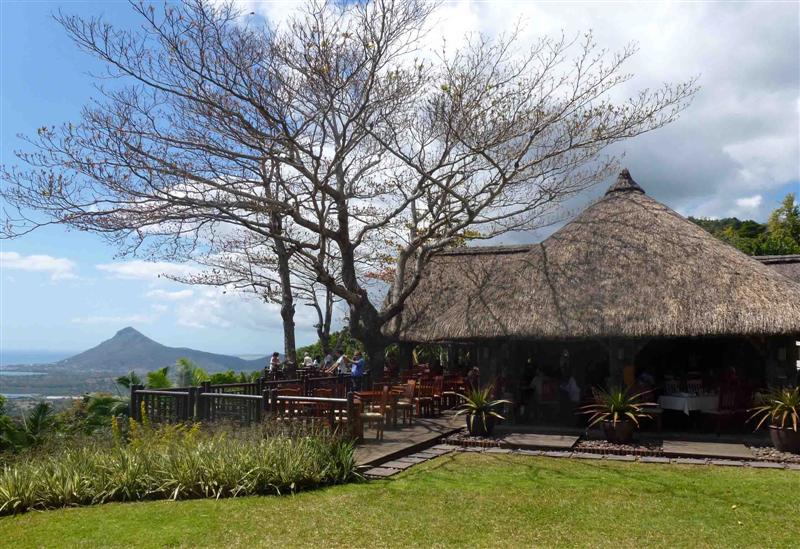
| Restaurant at Chamarel |
Lunch took us to the village of Chamarel, and a lovely restaurant set on the hillside above the Le Morne rock buttress at the south end of the island. From here we could see out over emerald green lagoons to the corral reefs that circle the island, while we dined on local seafood salad served in the shell.
 |
| Le Morne rock and lagoon from Chamarel restaurant |
 |
| Falls at Chamarel |
 |
| Chamarel Coloured Earth |
 |
| Tortoise at Chamarel |
Following lunch we took in the beautiful Chamarel Falls that plunge over a resistant layer of basalt, and took in the beautifully tinted “Chamarel Coloured Earth” – layers of volcanic “tuff” (welded ash flows) that have weathered to a striking array of colors from the variation of chemicals found in them. Here too are some large tortoises reintroduced from the Seychelle Islands to restore the native population that went extinct along with the Dodo during European settlement.
 |
| Sugar Cane fields along the west coast |
The final leg of our day was the drive north back to Port Louis, through some of the remnant sugar cane fields and along the coast. Our ship pulled out of Port Louis harbor after one last lovely sunset over the city, and we have recommenced our journey across the Indian Ocean. Mauritius was a lovely, unexpected short interlude. Now India beckons in only 5 days. But first we will pause for the 107th Semester at Sea Olympiad…
 |
| End of the Day in Port Louis, Mauritius |


No comments:
Post a Comment